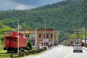
Hot Springs, North Carolina on the Appalachian Trail
The Hot Springs Access Point is, without a doubt, the best spot in Madison County to find the Appalachian Trail since the Trail runs right through the main street of the town (Bridge Street). How easy can that be! If you are not a hiker, you can simply stand on the sidewalk and “hike” the Trail.
In addition, you have many amenities such as a spa which pumps the hot mineral water into the hot tubs, restaurants, cabins, camping sites and an excellent side trail on Lover’s Leap which affords a wonderful view of the French Broad River. From Hot Springs on the Appalachian Trail, Tanyard Gap is 5.9 miles and Garenflo Gap is 6.6 miles.
Sites in Hot Springs:
There is a beautiful “side trip” onto Lover’s Leap Rock trail. From the rock outcrop, there are numerous overlooks with panoramic views of the French Broad River and the town of Hot Springs. There is a Cherokee legend that forms the basis for the name of the rock outcropping. The beautiful Indian princess, Mist on the Mountain, was in love with a tall, handsome brave from a different village named Magwa. She had, however, been promised by her father to the old and disgusting Tall Pine. Magwa’s request for the princess’s hand in marriage was refused by her father. So Mist on the Mountain sneaked out of her village to meet Magwa down by the river to escape in his canoe. Unfortunately, Tall Pine learned of this plan and killed Magwa whose body fell back into the canoe and floated down stream. Having seen this murder, Mist on the Mountain fled up a rock out-crop over the river. Upon reaching the top, with no place to go, her love’s spirit calling for her to join him, Mist on the Mountain jumped into the river to her death. This rock out-cropping is now know as “Lovers Leap Rock.”
Hot Springs Spa—(828) 622-7676. At the northern end of town, on the southern bank of the French Broad River, the spa offers baths and massages at the famous therapeutic mineral baths for which the town was named. Currently, the natural resource is piped into Jacuzzi baths of 105-degree water which can be rented by the hour. The springs have attracted people to the area since the late 1700s. The Natural Hot Mineral Springs were discovered in 1778 by a group of mountaineer white settlers. Artifacts found at these springs supported the claim that the Cherokee Indians used these springs and believed in their magical curative powers many years before they arrived. Hot Springs became known throughout the world because of its magical healing waters and lavish resort. During World War I, a detention center/prison was constructed on the spot to hold German prisoners of war, and many German-American prisoners enjoyed the springs so much that they stayed in the area after the war.
Driving Directions: GPS location = N35° 53′.32’ W082° 49′.45’
From Mars Hill: Take NC Highway 213 west toward Marshall. After 8 miles, turn right on US Highway 25N/70W toward Hot Springs. Continue for 11 miles and turn left to continue on US 25/70 for 5 miles into the town of Hot Springs.
From Marshall: Take US 25N/70W bypass toward Hot Springs. After about 10 miles, turn left to continue on US 25/70 for 5 miles into the town of Hot Springs.
From Asheville via I26: Take I26W to Exit 19 toward Hot Springs/Marshall–second 19 exit. Continue on US 25/70 for 21 miles. Turn left to continue on US 25/70 for 5 miles into the town of Hot Springs.
From Asheville via Leicester Highway NC 63: From Patton Avenue intersection of Leicester Highway/NC 63 for 26 miles. Merge with NC Highway 209 and continue for another 14 miles into the town of Hot Springs.
From I 40 Exit 24 (near Lake Junaluska: Take NC Highway 209 north for 33 miles into the town of Hot Springs.
From Tennessee Exit 435 (Newport, TN): Take US Highway 25E/70S for 25 miles. into the town of Hot Springs.
Hiking the Trail:
To hike south to Garenflo Gap
To hike south to Garenflo Gap (6.6 miles), from town you walk west on Bridge Street and continue on NC Highway 209 toward Spring Creek for about 2/10 of a mile and look for the AT Trail sign next to a utility pole with a white blaze on the right side of the road.
To hike north to Tanyard Gap
To hike north to Tanyard Gap (5.9 miles), from town you walk east on Bridge Street and cross the bridge over the French Broad River. You are actually walking on the Appalachian Trail at this point as it runs right through town. The sidewalks and roads have the diamond-shaped A.T. markers embedded in the concrete. Once you leave town, the AT will be marked with white blazes. Stay on the right side of the bridge and immediately after crossing the bridge there will be a guard rail with a path on the other side. Climb over the guard rail and follow the steps on the path on the embankment to the street below. Follow the street up river about 50 yards until you cross a wooden bridge. Continue on along the river and you will see white blazes marking the Appalachian Trail every 100 feet or so.


